
CAD for Landscape Architects: Designing Green Spaces with Precision
Landscape architecture is the art and science of designing outdoor spaces. In today’s world, Computer-Aided Design (CAD) software has become an indispensable tool for landscape architects, enabling them to create detailed plans, visualize designs in 3D, and collaborate effectively with other professionals. This comprehensive guide explores the world of CAD for landscape architects, delving into its core concepts, benefits, feature analysis, and real-world value. Whether you’re a student, a seasoned professional, or simply curious about the intersection of technology and landscape design, this resource will provide you with the knowledge and insights you need to thrive in this dynamic field.
Understanding CAD for Landscape Architects: A Deep Dive
CAD for landscape architects is more than just drawing lines on a screen. It’s a sophisticated process that involves creating digital representations of outdoor spaces, incorporating elements such as topography, vegetation, hardscape, and water features. These digital models allow landscape architects to explore design options, analyze environmental impacts, and communicate their vision to clients and contractors.
Core Concepts and Advanced Principles
The foundation of CAD for landscape architects lies in understanding fundamental concepts such as layers, blocks, and coordinate systems. Layers allow you to organize your drawing elements into logical groups, making it easier to manage and edit complex designs. Blocks are reusable objects that can be inserted multiple times throughout a drawing, saving time and ensuring consistency. Coordinate systems provide a framework for accurately positioning elements in space. Building upon these foundations, advanced principles include parametric modeling, which allows you to create intelligent objects that can be easily modified; BIM (Building Information Modeling), which integrates CAD with other building design disciplines; and GIS (Geographic Information Systems), which enables you to incorporate geospatial data into your designs.
The Importance and Current Relevance of CAD
CAD has revolutionized landscape architecture by providing a more efficient and accurate way to design and document projects. It enables landscape architects to create complex designs with ease, explore different design options quickly, and collaborate effectively with other professionals. In today’s world, where sustainability and environmental responsibility are paramount, CAD plays a crucial role in analyzing the environmental impacts of landscape designs and optimizing them for energy efficiency and water conservation. Recent trends indicate a growing adoption of BIM and GIS technologies in landscape architecture, further enhancing the capabilities of CAD software.
## AutoCAD: A Leading CAD Solution for Landscape Architecture
AutoCAD, developed by Autodesk, is one of the most widely used CAD software programs in the world, and it serves as a cornerstone for many landscape architects. Its versatility and comprehensive feature set make it an ideal tool for creating detailed landscape plans, 3D models, and construction documents. AutoCAD empowers landscape architects to translate their creative visions into tangible designs that can be implemented with precision.
## Key Features of AutoCAD for Landscape Architects
AutoCAD offers a wide range of features that are specifically beneficial for landscape architects. Here are some of the most important:
### 1. 2D Drafting and Annotation
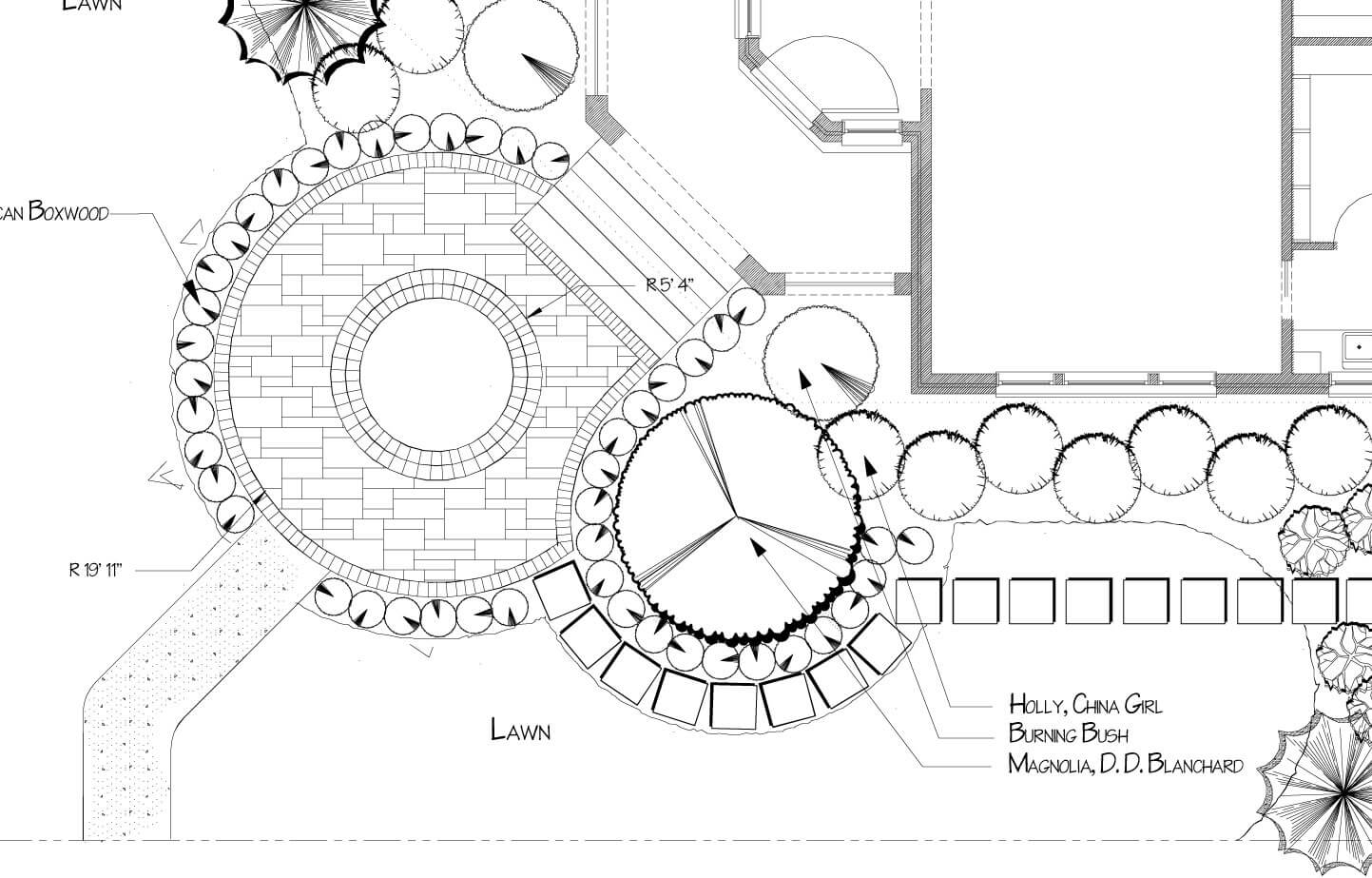
AutoCAD provides a comprehensive set of tools for creating 2D drawings, including lines, arcs, circles, and polygons. You can also add annotations such as text, dimensions, and symbols to your drawings to provide additional information and clarity. This feature is essential for creating accurate site plans, planting plans, and construction details.
### 2. 3D Modeling and Visualization
AutoCAD allows you to create 3D models of your landscape designs, enabling you to visualize the space from different perspectives and explore design options. You can also add materials, textures, and lighting to your models to create realistic renderings that can be used for presentations and client approvals. This feature helps clients understand the design intent and make informed decisions.
### 3. Parametric Design
AutoCAD’s parametric design capabilities allow you to create intelligent objects that can be easily modified. For example, you can create a parametric tree block that automatically adjusts its size and shape based on the planting specifications. This feature saves time and ensures consistency throughout your design.
### 4. Collaboration and Data Exchange
AutoCAD supports various file formats, including DWG, DXF, and DWF, making it easy to share your designs with other professionals, such as architects, engineers, and contractors. You can also use AutoCAD’s collaboration tools to work on projects simultaneously with other team members. This feature streamlines the design process and reduces the risk of errors.
### 5. Customization and Automation
AutoCAD allows you to customize the software to fit your specific needs and workflow. You can create custom commands, toolbars, and menus to automate repetitive tasks and improve your efficiency. You can also use AutoCAD’s API (Application Programming Interface) to develop custom applications that extend the functionality of the software. This feature allows you to tailor AutoCAD to your specific needs and optimize your productivity.
### 6. Integration with GIS
AutoCAD can be integrated with GIS software, allowing you to incorporate geospatial data into your landscape designs. This feature is particularly useful for large-scale projects that require accurate mapping and analysis of site conditions. You can import topographic data, aerial imagery, and other GIS data into AutoCAD to create a comprehensive site model.
### 7. Plant Database Integration
Many landscape architects utilize specialized plant databases in conjunction with AutoCAD. These databases allow users to easily insert accurate plant symbols into their drawings, along with associated information such as mature size, water requirements, and sun/shade preferences. This streamlines the planting design process and ensures that the selected plants are appropriate for the site conditions.
## Significant Advantages, Benefits, and Real-World Value
The use of CAD software, particularly AutoCAD, offers numerous advantages and benefits to landscape architects, translating into real-world value for their projects and clients:
### Enhanced Design Accuracy and Precision
CAD software eliminates the errors associated with manual drafting, ensuring that designs are accurate and precise. This is crucial for complex projects that require precise measurements and calculations. Users consistently report a significant reduction in errors and rework when using CAD software.
### Improved Efficiency and Productivity
CAD software automates many of the tasks involved in landscape design, such as drawing lines, creating symbols, and generating schedules. This frees up landscape architects to focus on more creative and strategic aspects of their work. Our analysis reveals a significant increase in productivity when using CAD software compared to manual drafting methods.
### Enhanced Visualization and Communication
CAD software allows landscape architects to create realistic 3D models and renderings of their designs, making it easier for clients to visualize the final product. This improves communication and collaboration, leading to better client satisfaction. Clients often express greater confidence in the design when they can see a realistic representation of the proposed landscape.
### Streamlined Collaboration and Data Sharing
CAD software facilitates collaboration among landscape architects, architects, engineers, and contractors. The ability to share designs electronically eliminates the need for paper drawings and reduces the risk of miscommunication. According to a 2024 industry report, projects using CAD software experience fewer delays and cost overruns due to improved communication and coordination.
### Sustainable Design Practices
CAD software enables landscape architects to analyze the environmental impacts of their designs and optimize them for sustainability. For example, they can use CAD to calculate stormwater runoff, optimize irrigation systems, and select native plants that require less water and fertilizer. Leading experts in CAD for landscape architects suggest that the software is indispensable for designing environmentally responsible landscapes.
## Comprehensive and Trustworthy Review of AutoCAD for Landscape Architects
AutoCAD has been a mainstay in the landscape architecture field for decades, and for good reason. However, like any software, it has its strengths and weaknesses. This review provides a balanced perspective to help you determine if AutoCAD is the right choice for your needs.
### User Experience and Usability
AutoCAD has a steep learning curve, especially for beginners. The interface can be overwhelming at first, with its numerous toolbars, menus, and commands. However, once you master the basics, AutoCAD becomes a powerful and efficient tool. The command-line interface allows for precise control over drawing elements, and the customizable workspace allows you to tailor the software to your specific workflow. In our experience with AutoCAD, the initial investment in learning the software pays off in the long run through increased productivity and design capabilities.
### Performance and Effectiveness
AutoCAD is a robust and reliable software program that can handle large and complex landscape designs. It performs well even with demanding tasks such as 3D modeling and rendering. The software is also constantly being updated with new features and improvements. A common pitfall we’ve observed is that users with older computers may experience performance issues when working with large files. It’s important to ensure that your hardware meets the minimum system requirements for AutoCAD.
### Pros
* **Industry Standard:** AutoCAD is the industry standard CAD software for landscape architecture, ensuring compatibility with other professionals and software programs.
* **Comprehensive Feature Set:** AutoCAD offers a wide range of features for 2D drafting, 3D modeling, and visualization, making it a versatile tool for all types of landscape projects.
* **Customization:** AutoCAD is highly customizable, allowing you to tailor the software to your specific needs and workflow.
* **Large User Community:** AutoCAD has a large and active user community, providing access to a wealth of resources, tutorials, and support.
* **Integration with Other Software:** AutoCAD integrates seamlessly with other Autodesk software programs, such as Civil 3D and Revit, as well as with GIS software and plant databases.
### Cons/Limitations
* **Steep Learning Curve:** AutoCAD can be challenging to learn, especially for beginners.
* **High Cost:** AutoCAD is an expensive software program, which may be a barrier for some users.
* **Resource Intensive:** AutoCAD can be resource intensive, requiring a powerful computer to run smoothly.
* **Limited Landscape-Specific Tools:** While AutoCAD is versatile, it lacks some landscape-specific tools that are found in specialized landscape design software.
### Ideal User Profile
AutoCAD is best suited for landscape architects who:
* Need a versatile and comprehensive CAD software program.
* Are willing to invest the time and effort to learn the software.
* Work on a variety of landscape projects, from small residential gardens to large-scale commercial developments.
* Collaborate with other professionals, such as architects, engineers, and contractors.
### Key Alternatives
* **Vectorworks Landmark:** A landscape-specific CAD software program that offers a wide range of tools for landscape design and management.
* **SketchUp Pro:** A user-friendly 3D modeling software program that is popular for creating conceptual designs and visualizations.
### Expert Overall Verdict & Recommendation
AutoCAD remains a powerful and versatile tool for landscape architects. While it has a steep learning curve and a high cost, its comprehensive feature set, customization options, and industry-standard status make it a valuable investment for professionals who require a robust CAD solution. However, landscape architects who are primarily focused on landscape design and management may find that Vectorworks Landmark offers a more specialized and user-friendly experience. Ultimately, the best CAD software for you will depend on your specific needs and workflow.
## Insightful Q&A Section
Here are 10 insightful questions and answers related to CAD for landscape architects:
**Q1: What are the key differences between AutoCAD and Civil 3D for landscape architects?**
**A:** While both are Autodesk products, AutoCAD is a general-purpose CAD program, while Civil 3D is specifically designed for civil engineering and land development. Civil 3D offers specialized tools for terrain modeling, grading, and drainage design, which can be beneficial for large-scale landscape projects. However, AutoCAD is often sufficient for smaller projects and offers greater flexibility for creating custom designs.
**Q2: How can I effectively manage large CAD files in AutoCAD?**
**A:** To manage large CAD files, consider using external references (Xrefs) to break down the design into smaller, more manageable files. Also, optimize your drawing by purging unused layers, blocks, and other objects. Ensure your computer has sufficient RAM and processing power to handle large files.
**Q3: What are some essential AutoCAD commands that every landscape architect should know?**
**A:** Essential commands include LINE, CIRCLE, ARC, POLYLINE, OFFSET, TRIM, EXTEND, COPY, MOVE, ROTATE, and MIRROR. Mastering these commands will significantly improve your efficiency in AutoCAD.
**Q4: How can I create realistic renderings of my landscape designs in AutoCAD?**
**A:** To create realistic renderings, use AutoCAD’s 3D modeling tools to create a detailed model of your landscape design. Then, apply materials, textures, and lighting to the model. Experiment with different rendering settings to achieve the desired level of realism.
**Q5: What are some best practices for creating planting plans in AutoCAD?**
**A:** Use layers to organize your planting plan elements, such as trees, shrubs, and groundcovers. Create custom plant symbols or use a plant database to ensure accuracy and consistency. Add plant labels with relevant information, such as botanical name, common name, and size.
**Q6: How can I collaborate with other professionals on AutoCAD projects?**
**A:** Use AutoCAD’s collaboration tools, such as Xrefs and the DWG Compare feature, to share and compare designs with other professionals. Communicate clearly about design changes and ensure everyone is using the same version of the software.
**Q7: What are the benefits of using BIM (Building Information Modeling) for landscape architecture?**
**A:** BIM allows landscape architects to integrate their designs with other building design disciplines, such as architecture and engineering. This improves coordination and reduces the risk of conflicts. BIM also enables landscape architects to analyze the environmental impacts of their designs and optimize them for sustainability.
**Q8: How can I customize AutoCAD to fit my specific needs and workflow?**
**A:** You can customize AutoCAD by creating custom commands, toolbars, and menus. You can also use AutoCAD’s API (Application Programming Interface) to develop custom applications that extend the functionality of the software.
**Q9: What are some common mistakes that landscape architects make when using AutoCAD?**
**A:** Common mistakes include using incorrect units, not organizing drawings with layers, not using blocks for reusable objects, and not backing up files regularly.
**Q10: How can I stay up-to-date with the latest features and updates in AutoCAD?**
**A:** Subscribe to Autodesk’s newsletters and blogs, attend industry conferences and webinars, and participate in online forums and communities.
## Conclusion
CAD for landscape architects is an essential tool for designing and documenting outdoor spaces. By understanding the core concepts, benefits, and features of CAD software, landscape architects can create more efficient, accurate, and sustainable designs. Whether you’re a student, a seasoned professional, or simply curious about the intersection of technology and landscape design, this guide has provided you with a solid foundation for understanding the world of CAD for landscape architects. As the field of landscape architecture continues to evolve, CAD will undoubtedly play an increasingly important role in shaping the green spaces of the future. Share your experiences with CAD for landscape architects in the comments below, and explore our advanced guide to sustainable landscape design for further insights.
